tOOLS USED TO mAP THE oCEAN fLOOR
Today’s technology lets scientists to study the ocean in a quicker and precise way. There are three tools used to map the ocean floor, sonar, satellites, and submersibles. Sonar is a type of electronic depth-sounding equiptment made in the 1920's.It is an acronym for sound navigation and ranging. Sonar is also known as echo sounding. Sonar navigates, communicates or detects objects on or under the surface of the water, such as other vessels. It is a tequnique that works by transmitting sound waves toward the ocean floor. There are two typeS of Sonar, simple and multibeam. They work in different ways, but gather the same information. With simple sonar, depth can be calculated from the speped of sound waves in water for every second it is about 1500 meters. The information also depends on the time needed for the energy pulse to reach the ocean floor. After this information is recieved, we can determine the depth of the oean floor and the depths determined from the information is plotted. A chart can be made by combining this information with information similar to it. Sometimes ships use multibeam sonar to gather the depth information needed. In this case, the ship moves through the area in a regular spaced back-and-forth pattern. This is known as "mowing the lawn.
Satelites measure depth in a different way. Satellites use the ocean surface to determine depth and landforms. Although the human eye cannot see the small differenced in the ocean-suface heigth, sattelites use exatly that to measure depth. Satellites use microwaves to find the small height differences, and the microwaves bounce off of the ocean suface. The height of the ocean surface can be calculated by knowing the exact position of the satellite. The satellites can measure very small diferences in sea-surface height. This data, like sonar, is also used to create detailed ocean floor maps.
A submersible is a small underwater craft used for deep-sea research. Submersibles, unlike sonar or satellite, can take videos and pictures of animals that live at the deepest points. They are equipped with many gadgets such as thermometer, pressure gauges, and cameras. Subemersibles can explore the abyssal areas that satellites cannot.
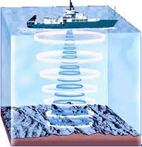
Simple Sonar- By using sonar, oceanographers can determine the depth of the ocean floor in a particular area. Figure 4 Sonar Methods- A- Science Textbook (Page 398)
|
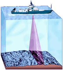
Modern multibeam sonar obtains a profile of a narrow swath of seafloor every few seconds- Figure 4 Sonar Methods- B- Science Textbook (Page 398)
|
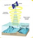
Satellites can be used to measure sea-surface height. The data colledted by satellites can be used to predict the location of large features on the seafloor. This method of data collection is much faster than using sonar- Figure 5 Satellite Method- Science Textbook (Page 399)
|
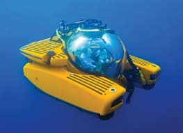
A submersible
|
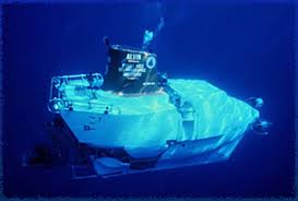
Alvin- a submersible
|
